:max_bytes(150000):strip_icc()/GettyImages-463758475-56706cc13df78ccc15cdd853.jpg)
After an exceptionally dry year in 2023, Iowa has started 2024 with above average precipitation. Despite that, though, the state has experienced its 187th consecutive week where at least D1 moderate drought is present within the state.
Justin Glisan, Iowa state climatologist, says that two recent storm systems brought “anywhere from five to 20 inches of snowpack on the ground,” in Iowa. Glisan says Iowa is currently in the strong El Niño phase, which could result in “warmer temperatures through the winter and a more active storm track.”
Typically, Glisan says winter in Iowa tends to be the driest season of the year. However, storm systems in December and January have made it so this winter is so far well above normal precipitation, he added.
Although precipitation currently is above normal this winter, Glisan says because the U.S. is in a strong El Niño phase, Iowa should expect less snowfall than average. December was recorded as the 12th-least snowy on record, he says.
Glisan says Iowa is currently experiencing the longest drought the state has seen since an extended drought from 1954 to 1958.
Despite the long drought, Glisan says improvements in crop technology have allowed farmers to produce record yields in 2021 and near-record yields in 2022. Following 2022, though, 2023 was reported as the 22nd-driest year on record, Glisan says. He says 2019 to 2023 was the fifth-driest four-year period in recorded history for Iowa.
”If we don’t get timely rainfall through the growing season,” Glisan says, “we’re going to continue to deplete soil moisture profiles due to vegetative demands.”
Dennis Todey, director of the USDA Midwest Climate Hub, says it’s still too early to tell what kind of an impact recent snowstorms have had on improving drought conditions and helping with soil recovery for spring planting across the Midwest. Todey says rains in late December did help in varying amounts across the Midwestern states.
:max_bytes(150000):strip_icc()/IMG_10051-c5a6dfe14b664f3c9ddbde8825e18699.jpg)
Drought Monitor
When it comes to drought conditions in Iowa, Todey says the state is “fighting such large deficits in some places that even an inch or more of rain in December didn’t nudge conditions on the [drought monitor map].”
While the drought monitor map didn’t show improvements in drought conditions from December rainfall in Iowa, Todey says the precipitation that did fall was able to soak into the ground because the soils were warm from a warmer than normal December and not frozen.
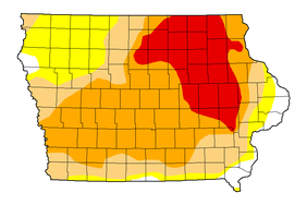
The latest drought monitor map shows 24% of Iowa’s acres are in D3 extreme drought, 36% are in D2 severe drought, 20% are in D1 moderate drought, and 16% are abnormally dry. Just 4% of the state’s acres are free from drought stress.
Regarding the recent storms that brought snow to Iowa, Todey says the snowfall will be helpful for runoff, “but will unlikely do much for soil moisture.”
The soils in the Corn Belt have a significant capacity for more precipitation, Todey says.
“We really need several more one or more inches of rain in some of the driest areas to really feel good about going into spring,” he adds.

